LiDAR stands for Light Detection and Ranging. This technology isn’t new but it has all kinds of new applications. Self driving cars, camera focusing, construction, atmospheric science, measuring ice thickness and many many more. The method is simple: a pulse of laser light is fired from source, and then a very sensitive clock counts the length of time for the laser light to bounce off of something and return to the detector. The detector measures the intensity of the light that is returned. LiDAR then repeats the measurement millions of times. Taken together, a cloud of range and intensity measurements draws a three-dimensional picture of the target and the surface roughness. Rough surfaces have high intensity while smooth surfaces have low LiDAR intensity.
I go in the field with a LiDAR on a tripod and build 3D models of volcanic ash beds, lava flows and lava tubes.
Valentine Cave Lava Tube is in northern California at Medicine Lake Volcano. These data were collected as part of the NASA funded project TUBE-X concerned with developing exploration strategies for lava tubes on the moon. NASA’s GEODES team is expanding on that work to include more targets and more geophysical techniques.
Different kinds of lava have different surface roughness. Smooth pāhoehoe lava or rough ʻaʻā are the extreme examples, there are many other types of lava that are middle cases, and each have a different roughness signature that can be measured with LiDAR.
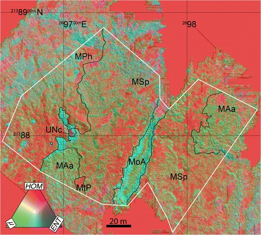
In this map, of the Muliwai a Pele Lava Channel, Mauna Ulu, Hawai‘i, the lava is colorized by its LiDAR roughness. The central lava channel (MoA) had fast moving lava that is very rough (green) while other parts of the lava flow (MPh) had slow moving smooth (red and purple) pāhoehoe lava.
More to come!

Leave a comment